Powered by Vacations To Go, with over 10 million happy customers since 1984
Map of Hawaii
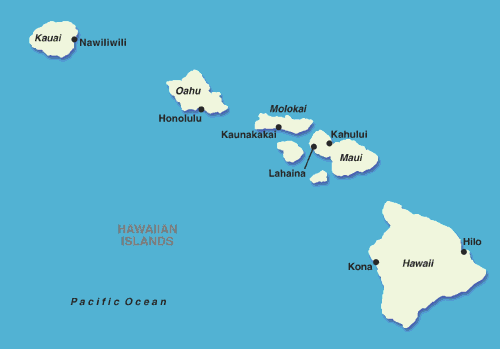
The 50th state of the union and former monarchy, Hawaii, is composed of six major islands and sits far out in the Pacific Ocean. Kauai, Oahu, Molokai, Lanai, Maui and Hawaii's Big Island form the archipelago.
The Aloha State, which lays claim to both surfing and the hula, joined the U.S. in 1959. Hawaii's closest neighboring state is California, but the distance doesn't seem very neighborly. Honolulu is 2,556 miles from Los Angeles. Historically the islands were difficult to access, but modern technology has made them easily reachable; a flight to Honolulu from Los Angeles takes around five and a half hours.
Each of the six islands boasts a unique character and interesting attractions. The Big Island of Hawaii is larger than all the other islands combined. It's the southernmost island in the chain, and cruise ships often call at Hilo on the northeast side. Home to the world's most active volcano, Kilauea, Hawaii's Big Island grows larger every day.
The island of Oahu is home to the state's capital city, Honolulu, which has a distinct cosmopolitan feel. Kauai, farthest to the north, is known as the "garden isle" because of its lush greenery. The uncrowded island is where visitors can find the stunning Waimea Canyon. Cruises traveling to Kauai stop at Nawiliwili on the southeastern side of the island.